|
|
 |

September 14, 1999
For: Public 502 hearing
The following opinion was prepared as testimony regarding the proposed Missisquoi Bay Bridge. The opinions stated here do not necessarily reflect the water company membership.
Ron Haskell
President/Treasurer
Alburg Springs Water Co., Inc.
|
The Alburg Springs Water Co. is a small, community water system subject to the rules and regulations set forth by the Vermont Agency of Natural Resources and the federal Environmental Protection Agency. We have 28 active hook-ups serving 100 or so people. Our water source is Lake Champlains Missisquoi Bay.
The company uses a filtration system to remove detritus and algae from the raw water combined with chlorination to kill micro-organisms. Our system has, fortunately, been able to keep ahead of the above average algae bloom of 1999 through rigorous backwashing. We are able to clear the filters of material
|
|
that would otherwise clog and render them unuseable. In fact, in early August the system was shut down for nearly two weeks as a result of the bloom, which apparently became established as a growth in one tank and caused the media to literally float up, spill into the pipes, and damage the control valves.
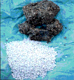
In 1996, the company replaced the media after encountering problems with our "make water" cycle. The picture here shows two samples of filtration media.At the bottom is the new media, as free flowing as gravel can be. At the top is the old media, a solid lump of gravel held together by accummulated mud and debris.
|
|
|
When our system was designed and installed in 1984, certain engineering assumptions were incorporated based on water quality. The size of the intake line, pump capacities, filtration capacities, and backwash frequency were presumably set up to accommodate the needs of the system as well as the need to meet water quality standards. We believe that those original assumptions no longer apply to the current state of the Missisquoi Bay. Further, we think our system, though marginally capable of satisfying the competing needs of water provision vs. regulatory requirement, is in danger of being overwhelmed by the continuing poor quality of water in the bay.
The algae bloom of 1999 seems to be one of the worst on record. As a fisherman, Im well aware of the bloom cycles on the lake and the likelihood of a bloom in the warm, low water of summer. But I have also seen blooms in the fall in the Missisquoi Bay, blooms evidenced by a 2-3" deep sludge up against the shore. It is not an appealing sight.
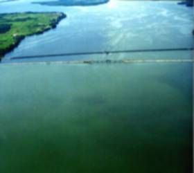
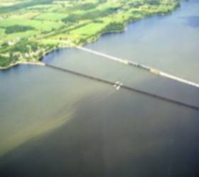
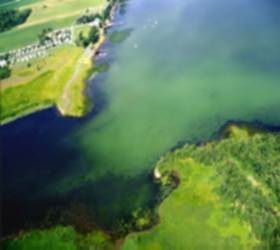
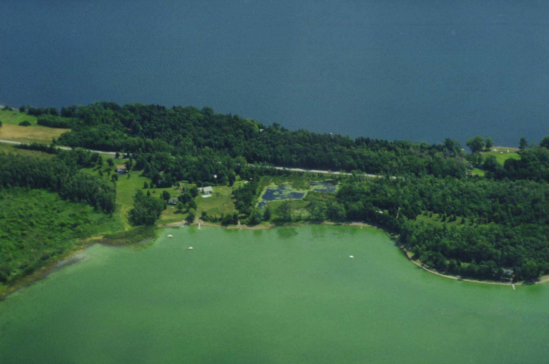
The following aerial pictures were taken in the second week of August 1999. At left is a view looking south with the existing Missisquoi Bay Bridge in the foreground. Algae growth can be clearly seen all across the north side of the causeway and, on the south, along the western half of the channel. The picture to the right shows how alga is "flowing" in the channel.
|
|
|
|
|
Notwithstanding the beauty of photographs such as this one of a channel at the Missisquoi River delta, I am appalled at the way ANR is managing the bay. On one hand, the biologists are concerned (and maybe/maybe not doing anything about it) with the phosphorus entering the lake
|
|
via Missisquoi River and its watershed. As the water quality deteriorates, those of us who draw from the lake have an increasingly difficult time making it potable. On the other hand, another group of biologists think protecting an apparently wide-ranging, adaptable turtle and marginal fish habitat is most important.
At present, most of the people on the Missisquoi Bay, i.e., the portion of the Inland Sea north of the existing bridge/causeway, favor a shore-to-shore bridge with removal of the existing causeway. We think the turtle
|
|
|
will find a new home readily, just as it apparently found the silt that gathered around the existing bridge (or adapted to the construction of the old bridge, as the case may be). We think the fish habitat throughout the entire bay will improve once the causeway is removed.
Although the Applied Sciences hydrodynamic study was not optimistic in predicting phosphorus reductions, part of their prediction was based on the "little mixing between water masses (from Missisquoi Bay to the rest of the Inland Sea)". This provokes a thought: How might one increase the mixing of water and enhance the flushing of the bay? The answer is evident: Do everything possible to remove obstacles restricting the flow!
Removing existing causeways is critical to encouraging the flushing of the bay. Removing the bay bridge causeway is one obvious step. Others include removing abandoned railroad causeways such as those connecting the islands to each other and the mainland. I suggest that it is time to consider a replacement to the Sandbar causeway, as well. In the absence of complete removal, an alternative is to open additonal channels through the existing causeways.
State and federal authorities expect our small community water system to have a water source protection plan. At the top of my list of protection measures is "Encourage creation of a coherent natural resource management plan that restores Lake Champlain and its watershed to a natural state." Such a policy would protect the interests of turtles as well as people. I have little concern but that under all circumstances the turtle will readily find a new place to spawn and hibernate. On the other hand, I am enormously concerned with the difficulty our water system will have in finding a new, suitable water source.
|
|
|
I dont profess to know all the ecological and political issues dominating the choices made by ANR executive management. I dont profess to have very many answers of my own design. But I can see where the current ANR policy is heading concerning the bay. Leave the causeway in place, and the bay will finish filling in. This might not be so bada great wetlands to filter our drinking water! Unfortunately, I dont think our little water company can hold out that long. Nor can many of the businesses, such as Campbells Bay Campground, at left, which rely on the physical appearance of the lake as much
|
|
as they rely on the potential potability of the water in order to attract customers.
Turning this presentation into an attack on the ANR would be all too easy, but that is not my intent. However, as a significant partner, for better or ill, in the choices that must be made regarding the bay bridge replacement, the ANR must be made to see that keeping the causeway intact ultimately condemns the Missisquoi Bay to a slow death. On the other hand, establishing and enforcing policies that minimize transport of pollutants to the bay and that encourage the free exchange of water between the bay and the Inland Sea, as well as into the main lake, are essential to the health and well-being of those of us who draw water from the bay, and those of us who rely on the bay for our livelihood.
I must wonder whether all the blather about turtles and habitat and removing the causeway is nothing more than smokescreen. Maybe a few ecologically-minded people are honestly concerned about the welfare of other species. But theres little doubt about what is motivating many choices in this situation: water quality throughout the Inland Sea.
|
|
|
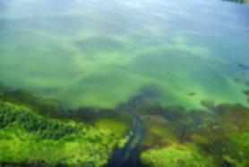
This picture is perhaps the most startling image of all those offered here. More than anything, this picture summarizes the issue of water quality and the impact of obstructions. Simply put, on which side of this neck would you want to own property or draw your drinking water?
Is removal of the causeway likely to be a magic bullet leading to instant clarity of the water in the bay? Not likely, and no one expects that to be the case. Will removal of the causeway produce a furor in the rest of
|
|
the northeast arm? Most definitely, and everyone expects that to be the case. After all, who in their right mind would want this stuff floating near them, much less in their drinking water?
This opinion and the photo of filter media was prepared by Ron Haskell, September 1999. All Rights Reserved.
The aerial photos were generously provided by Bob McEwen of Isle La Motte.
|
|
|
